Clothing Policy for Participants in the United Nations Command Demilitarized Zone (DMZ) Education and Orientation Program- Joint Security Area (JSA).
All visitors to the JSA must display a neat and presentable appearance. To meet this requirement the following standards apply:
Informal civilian cloths commonly viewed as acceptable in equivalent public settings are normally acceptable. For example, clean jeans without fraying or tearing and a clean t-shirt with running shoes are considered appropriate. However, ripped jeans, a t-shirt lettered with profanity, and flip-flop sandals would be deemed unacceptable. Visitors wearing clothing deemed faddish, extreme, torn, tattered, frayed, overly provocative, or otherwise inappropriate by the UNCSB-JSA guides will not be allowed to enter the DMZ. The following attire/appearance is specifically prohibited:
(1) Shirts/ tops without sleeves or that expose the midriff and tank tops. Also, shirts/tops insulting, profane, provocative or demeaning representations.
(2) Frayed cutoff shorts, gym shorts and shorts that expose the buttocks.
(3) Sports uniforms or athletic clothing of any kind including track pants or other stretch up or warm-up pants.
(4) Shower and flip-flop shoes.
(5) Items of military clothing not worn as an integral part of a prescribed service uniform.
(6) Oversize clothing, commonly referred to as “gangster” cloths, including oversize baggy/long pants, t-shirts, or sweatshirts, and “biker” dress such as leather vests and leather riding chaps.
United Nations Command Dress Code Disclaimer
Yet another unholy Saturday morning. Up at 6am and running out the door a moment later. Flagging down a taxi we rushed across the city headed for USO Camp Kim. We walked into this American Army Base in downtown Seoul while sipping on cheap coffee beverages out of a can. We signed into our tour and spent the next several minutes slumped into arm chairs in the reading room.
I am what you would call an advocate of non violence. I have many issues with the American Military and it was an odd feeling to be sitting inside their family room. Sort of like the reoccurring dream where I wake up as George Bush’s son. Heaven help me. The table in front of me was covered in military magazines and newspapers. I picked up The Military Times and appreciated that this publication is read by thousands of men and woman sitting in Army Bases across the world. The front page featured a man standing proudly in his military attire with a headline that read:
SUPER FRAUD: Kicked out as a private, he claimed bogus rank, medals and even disability. But his “battle scars” were liposuction. Now he faces prison.
The Army Times has a bit of a National Enquirer slant to it wouldn’t you say? I flipped through the pages to see if there was any mention of The Bat Boy or Killer Mermaids off the coast of Long Island. We walked down the halls of Camp Kim and I stared up at several posters of the various USO Cheerleading tours who have visited the Seoul Base. These women are busty. I couldn’t help but wonder if they had any other forms of entertainment. Such as reenactments of Flash Dance or Bette Midler Karaoke nights.
Everyone was soon gathering outside in front of two hummers and a barbed wire fence. Amy and I walked up the steps to our tour bus and were introduced to our rather eccentric Korean tour guide for the day. He wore massive pink glitter sun glasses and spoke with an Italian accent. You couldn’t miss him.
We spent the next hour driving north, to the most heavily armed border in the world. The crazy tour guide started to ramble on about random facts about the DMZ’s history and I jotted them down on my note pad.
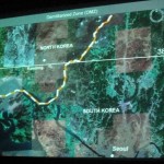
The Korean DMZ is a strip of land running across the Korean Peninsula that serves as a buffer zone between North and South Korea. It cuts the Peninsula roughly in half, crossing the 38th parallel on an angle, with the west end of the DMZ lying south of the parallel and the east end lying north of it. It is 155 miles long and approximately 2.5 miles wide.
Both the North and South remained heavily dependent on their sponsor states from 1948 through to the outbreak of the Korean War. The conflict, which claimed over three million lives and divided the Korean peninsula, commenced on June 25th 1950, with a Soviet sponsored DPRK invasion across the DMZ, and ended in 1953 after an international intervention pushed the front of the war back to near the 38th parallel. In the ceasefire of July 27th 1953, the DMZ was created as each side agreed in the armistice to move their troops back 2,000 meters from the front line. The Military Demarcation Line (MDL) goes down the center of the DMZ and indicated exactly where the front was when agreement was signed. Since the armistice agreement was never followed by a peace treaty, the two Koreas are still technically at war.
Owing to this theoretical stalemate, and genuine hostility between the North and South, large numbers of troops are still stationed along both sides of the line. Soldiers from both sides may patrol inside the DMZ, but they may not cross the MDL. Sporadic outbreaks of violence due to North Korean hostilities has killed over 500 South Korean soldiers and 50 U.S soldiers along the DMZ between 1953 and 1999.
I sat on the bus fidgeting with my fingers. On an international stage, North Korea has been causing several tension filled moments in the last few months: firing several missiles over South Korean airspace, avoiding talks with the UN regarding their nuclear program and the refusal to accept foreign aid as summer famine and drought season is quickly approaching. It is hard to describe the somewhat unsettling mood one feels while on a chartered bus heading into a war zone.
As we left the massive populace of Seoul the condominiums fettered out and small rural communities could be seen from the highway. Suddenly the bus swerved off the Han River and we were now driving up Freedom Road (the highway connecting Seoul to Panmunjom, DMZ territory). The city far behind us, I stared out at miles and miles of rice paddy fields lined by barbed wire fence and military look-out towers. As we neared Panmunjom the bus drove over a massive bridge with large yellow barriers blocking the road at regular increments. Our bus swerved through this maze of barriers until we reached the end of the bridge and drove to the entrance of Camp Bonifas.
Two towering black men wearing UN badges walked onto the bus and checked our Passport’s before telling us to switch buses. We drove on our new military bus while our new UN tour guide motioned us to look to our left as we passed the worlds most dangerous golf course (a one hole golf course surrounded by land mines).
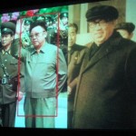
We hopped off the bus and entered a large debriefing auditorium where we were given official United Nations Command Visitor tags which we clipped to our shirts. We were given a clipboard and consent form which we had to sign. Basically indicating that we knew we were entering a war zone. For the next twenty minutes we enjoyed a very informative slide show which was presented by a UN commentator. He explained the history of the DMZ and the UN’s presence here (which is mostly made up of Swedes, French and the Swiss). We were shown pictures of South Korean military personnel as well as the North’s so we knew how to differentiate the two. Basically a “don’t accept candy from strangers,” moment. I found it rather funny that we were blatantly told “not to fraternize with the North Korean military personnel.” Like I am about to wave “yoo hoo,” to the Commie scum.
The famous Axe Murder Incident of August 1976 was described in detail in order to communicate to the guests of the United Nations Command how dangerous the Joint Security Area can be. The Axe Murder Incident involved the attempted trimming of a poplar tree which resulted in two American Army deaths by North Korean forces. Before this time, the soldiers of both sides were permitted to go back and forth across the MDL inside of the JSA, a privilege since revoked as a result of this incident.
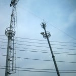
We were soon quietly driving through the DMZ. We were told to put away our cameras and I could see huge signs which read “Photography restriction, You are now entering the Korean Demilitarized Zone.” You could have heard a pin drop. Everyone stared out the windows in awe. While driving through the DMZ we passed through thick forests which would all of a sudden disappear. The trees had been knocked down and for miles and miles all you could see on both sides of the bus were huge armored towers covered in barbed wire. I had never seen anything like it. I felt like I was on the set of a dubious film. The movies plot revolves around a secret military building which houses aliens or giant man eating worms.
I felt a bit of hesitation in the air as our bus stopped at the Unification Building, which was built with the intention of reuniting Korean families who have been separated since the outbreak of the Korean War. The building is massive and ornate with white marble floors, crystal chandeliers and green velvet Victorian arm chairs. This last detail will always stick out in my mind as odd. Along the perimeter of the ground floor you will find maybe fifty green velvet arm chairs. Who on earth sits in these chairs? There was also a small office desk to the right side of the main doors which had an antique black phone and two yellow HB pencils sitting on its corner. It all seemed very odd, seeing that the only people to ever walk through this building were tour groups and military personal. I can’t imagine anyone is “waiting for a call.” I am most certain you are never asked to “wait in the lobby on one of the green velvet antique chairs.”
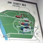
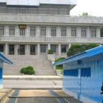
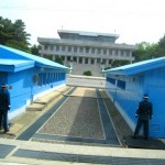
We walked up two flights of stairs single file through a set of two glass doors. And then, all of a sudden I was standing in the Joint Security Area looking across several long blue buildings at a North Korean Officer.
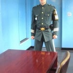
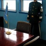
The JSA is the only place where the North and South connect. There are several buildings on both the north and south side of the MDL, and a few which are built right on top of the MDL. The JSA is the location where all negotiations since 1953 have been held. The MDL goes through the conference rooms and down the middle of the conference tables where the North Koreans and the United Nations Command meet face to face. Our group stood in a single file line and walked into one of these blue conference rooms. The room is full of mahogany desks and leather chairs. Our guide told half of the group to walk to the far end of the building. Moments later they were told that they were officially standing in North Korea. I was standing in an incredibly famous building which sits at one of the most monumental conflict zones of the Cold War.
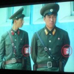
Two South Korean Military Personnel stood in the room with us. We were told they were here for our protection. These two boys were a hoot. They stand with their fists clenched at their sides (which is the traditional ready-to-attack Tae Kwon Do stance). All South Korean Military at the DMZ must wear Ray Ban aviator sunglasses. They wear these sunglasses to intimidate the North Koreans who stare at them 24 hours a day just meters away from the MDL. I peaked out the buildings window and noticed soliders standing half exposed at the end of each of the buildings, facing towards North Korea. We were told they stand behind these buildings with only half of their body showing in order to reduce their chances of being shot while on duty.
There were several American families from the army base in Seoul on our tour bus who said the most ridiculous things throughout the day. They all had southern accents. One of the families drove me insane. The father, daughter and mother had permanent smiles smacked onto their faces. They acted like Prozac addicted Zombies. This one particular mother clenched the cross that hung from her neck whenever we were told of a lost soldier or gruesome war details. She often muttered, “Lord Almighty.” I felt as though this church family may have been heading for a Disney Vacation and ended up on the wrong tour bus. I couldn’t help but laugh at this particular family while we were in the conference room .The three of them slowly crept to the North Korean end of the building and stood approximately one foot from one of the battle ready soldiers. The father threw his hands affectionately over his daughter and wife’s shoulders and posed for a photograph (with the creepy faux extreme happiness faces still present). Amy and I stood at the North Korean end of the building and I waved my peace signs through the air. A poetic attempt to saturate the country with peace, freedom and gaiety.
We hopped back into the bus and drove up a small hill and stopped at the top to look out over the lower valley. We were surrounded on all sides by North Korea. Located at the very tip of South Korea, the farthest you could safely tred in the DMZ. A few meters away we could see a North Korean lookout tower (again we were told to refrain from fraternization). I had to ask, “would swapping secret recipes be considered fraternization or culinary diplomacy?”
Within the DMZ there are two villages: one run by the North and the other by the South. Both are located near the JSA. Daeseong-dong, found on the southern side of the DMZ, is a traditional village and strictly controlled by the South Korean government. For instance, one must have ancestral connections to the village in order to live there. These restrictions serve to keep the population of the village very small.
In the North, Gijeong-dong, or as it is called in North Korea, “Peace Village,” has only a small caretaker population. Through the armistice agreement the North felt that it should be allowed a town within the borders of the DMZ since the South already had one. UN troops call this Propoganda Village because only a small group of people cleaning and turning on lights reside within the village. Although from afar it appears to be a modern village, one can tell with binoculars that there is no glass within the windows of the buildings. In the past, North Korean propaganda was sent out by loudspeaker across to Daeseong-dong for as much as 20 hours per day, and reciprocal pop music and South Korean exhortations blasted back. These broadcasts ceased by mutual agreement in 2004.
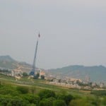
It’s rather odd to know that the village I was looking at didn’t actually have any inhabitants. It became more and more apparent throughout the day that North Korea is hell bent on lying about just about anything regardless if it makes them look moronic. Further evidence: During the 1980s, the South Korean government built a 328 foot flagpole in Daeseong-dong. The North Korean government responded by building a taller one – the tallest in the world at 525 feet in Kijong-gong, “Peace Village.” The flagpole is huge and dwarves the faux apartment buildings of the village bellow. I love that the Commies fondly call it Peace Village. I assume because it is always full of Peace and Quiet.
We all hopped back onto the bus and listened to our expert guide as we drove through Daeseong-dong South Korean village. He told us that the rice farmers who work in the DMZ are exempt from all taxes and make about $80 000 USD a year. A cute little grandmother from New Zealand turned to her friend and said, “Good Lord, marry one of these farmers Barbara, they make more money then we do!”
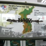
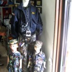
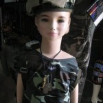
We stopped off at a gift shop which featured several incredibly cheesy DMZ items for purchase. Such as, military uniforms for babies and children, mugs which read “Freedom is not Free, and neither is this mug,” cheap jewelry, a frame which contains a rusted portion of DMZ barbed wire and bags of DMZ rice. I almost bought a small bag labeled “DMZ Rice: the most heavily guarded rice in the world.” I suppose this is the rice grown in the DMZ by local farmers. At tourist prices no wonder they make $80 000 a year!
We drove through forest for a few more minutes and were told that humans for the most part have not entered the DMZ in the last fifty years. This isolation has created as a byproduct one of the most well-preserved pieces of temperate land in the world. Environmentalists hope that if reunification occurs the former DMZ will become a wildlife refuge. However, there will be significant obstacles to maintaining the site because of the high concentration of landmines across the area.
Hopping back onto the bus we rushed up a steep hill to the DMZ Observatory which overlooks the North Korean Propoganda Village and the surrounding valley. The building is painted a tacky black, green and brown military design. I found this area hilarious as we ran into a huge throng of Korean tourists standing about ten meters from the edge of the viewing platform. They were standing behind a thick yellow line which read “Photography Line.” We were not allowed to take any pictures from the edge of the platform for safety reasons. I stared at what seemed like hundreds of little Korean Ajimas (grandmothers who have poorly permed hair held back by a massive sun visor.) These Ajimas stood behind the yellow line and jumped into the air with their cameras stretched over their heads. I can’t imagine any of the surely blurry pictures were worth the physical effort of the jump…but their effort was realized and much appreciated.
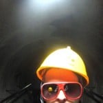
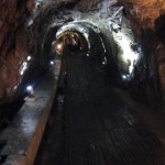
Our last stop of the day was the Third Tunnel. We drove to the tunnel entrance (which is now effectively a museum). We spent the next few minutes walking through the tunnel museum and sat in a large theater to watch an informative film about the tunnel which we would soon be hiking through.
Starting on November 15th 1974 the South discovered four tunnels leading under the DMZ. The first was discovered by a South Korean Army patrol, noticing steam rising from the ground. The initial discovery was met with a machine gun fire from the North Korean soldiers. This first tunnel was about three feet by four feet and extended over 1,000 meters beyond the Military Demarcation Line. When the first tunnel was discovered, it was reinforced with concrete slabs, electric power and lighting, weapons storage and sleeping areas and had a narrow gauge railway with carts, capable of allowing approximately 2,000 soldiers per hour to transverse it.
The tunnels were dug by North Korea and are presumed for use by the military as an invasion route. Each tunnel is large enough to permit the passage of an entire division in one hour. All the tunnels run in a north-south direction and do not branch off. The planning for the tunnels got progressively more advanced (for example, the third tunnel slopes upward slightly as it progresses southward, so that water does not stagnate). The orientation of the blasting lines within each one indicate that North Korea dug the tunnels. Upon their discovery, the North claimed that they were for coal mining; however, no coal can be found in the tunnels, which are dug through granite, but some of the tunnel walls were at some point painted black to give the appearance of coal. North Korea is clearly full of idiots.
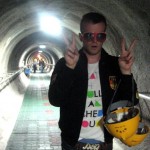
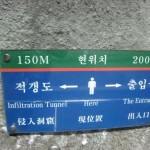
We were given yellow hard hats and walked down the tourist tunnel which the South Korean government built to easily connect to the base of the Third Tunnel. We walked steeply down a ramp which seemed as though it may never end. Walking to the middle of the earth and then some. The walls of the tunnel were dripping and covered in wet moss. Finally at the bottom we walked single file through North Korea’s most famous invasion attempt. Thank goodness for the hard hats. My helmet scraped across the tunnel roof several times. The tunnel was damp, sticky and smelled of earth and moss. It was dark but dimly lit by overhead lamps. I crouched down and imagined myself as a North Korean soldier ready to sneak attack the South. I would have been terrified, probably hungry and desperate for Paris Vogue Homme. Amy and I were the first to reach the end of the tunnel. A bit of an eerie site. Bright spot lights shine yellow beams through the restricted end of the tunnel which is covered in barbed wire and metal fencing. We were told that once South Korea discovered the tunnel the North covered the area with hundreds of land mines. Walking past the barbed wire would mean sudden death. It’s a bit freaky to stand at the end of this infamous tunnel to know that North Korea is just through the darkness. I expected a crazy screaming Commy to run through the barbed wire shooting an automatic weapon. Our imaginations make reality much more interesting. Most disturbing were the yellow painted walls where landmines were removed from the tunnel walls. I quickly walked out of the tunnel and stood at the entrance to the exit ramp. I breathed deeply and readied myself for the painful, never ending, steep, walk uphill.
I sat at the tunnel entrance across from yet another gift shop and stared at each person as they slowly huffed and puffed out of the dark and into the light of day. Some of the more obese tourists looked as though they had enjoyed a swim as their shirts were soaked through from sweating. I think a good reminder that they may need to cut back on the beer and potato chips. Sweaty men with beer guts…a horrific image. Shudder.
I was exhausted and ready for the drive back to Seoul. Our bus sped back to Camp Bonifas where we transferred back into our USO bus and sped through the forest towards Freedom Road. I spent the next hour staring out the afternoon sun filled sky as our bus drove along barbed wire fencing. Suddenly we were back in Seoul, surrounded by Coca Cola and McDonald’s advertisements. A short sigh, I do love the free world.